
A major project that could see a former oil depot overlooking Falmouth Docks be turned into homes and public parkland has been revealed.
The proposed scheme centres around the old oil depot in Castle Drive.
It is made up of two four-bedroom houses, two three-bedroom houses and a pair of two-bedroom houses, all of which would be single storey apart from one that would have a small area of lower ground accommodation.
As part of the application, an area of 0.98 hectares below Ships and Castles leisure centre would be gifted to Falmouth Town Council "so that the public can enjoy the expansive views back across the town and the harbour."
The park access would be off Castle Drive in two locations – one stepped and the other on a slight ramped incline – and include a path network that would integrate the historic World War Two trenches.
Plans include a dedicated bat house, to provide mitigation for loss of roosts, as well as general bird boxes on the new houses, bee bricks in the buildings, a second log pile for reptiles, insects and hedgehogs, and the extension of the Cornish hedge on the southern boundary.
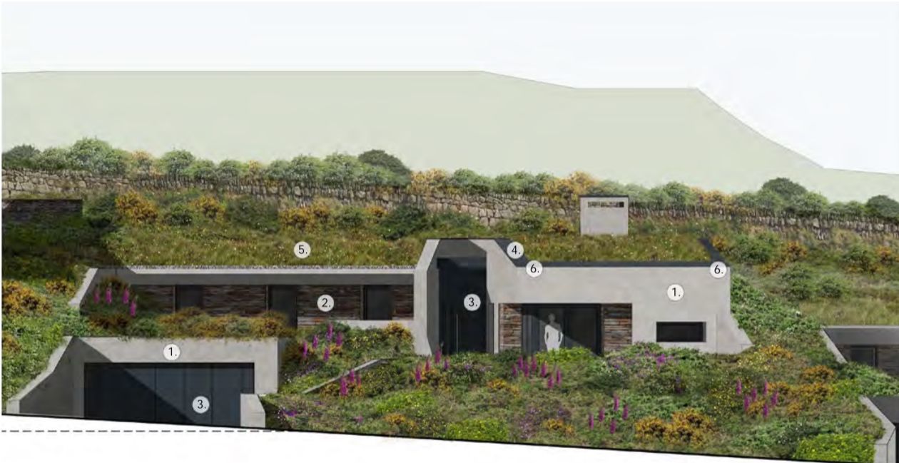
How the houses could look Picture: Lavigne Lonsdale
Details have been revealed in a pre-application enquiry to Cornwall Council by masterplanners and architecture first Lavigne Lonsdale, working on behalf of Castle Drive Developments Ltd.
Such applications are made by companies to get the view of planning officers on a project, before submitting any planning application.
The council's website shows that advice has been given, but no details of what was said.
In a draft design and access statement, Lavigne Lonsdale said it had taken three years to get to this stage, with the plans reworked three times already following feedback from Historic England and other consultants.
It states the project had been "scaled back significantly" from an original proposal of 39 units, with a mix of apartments and houses.
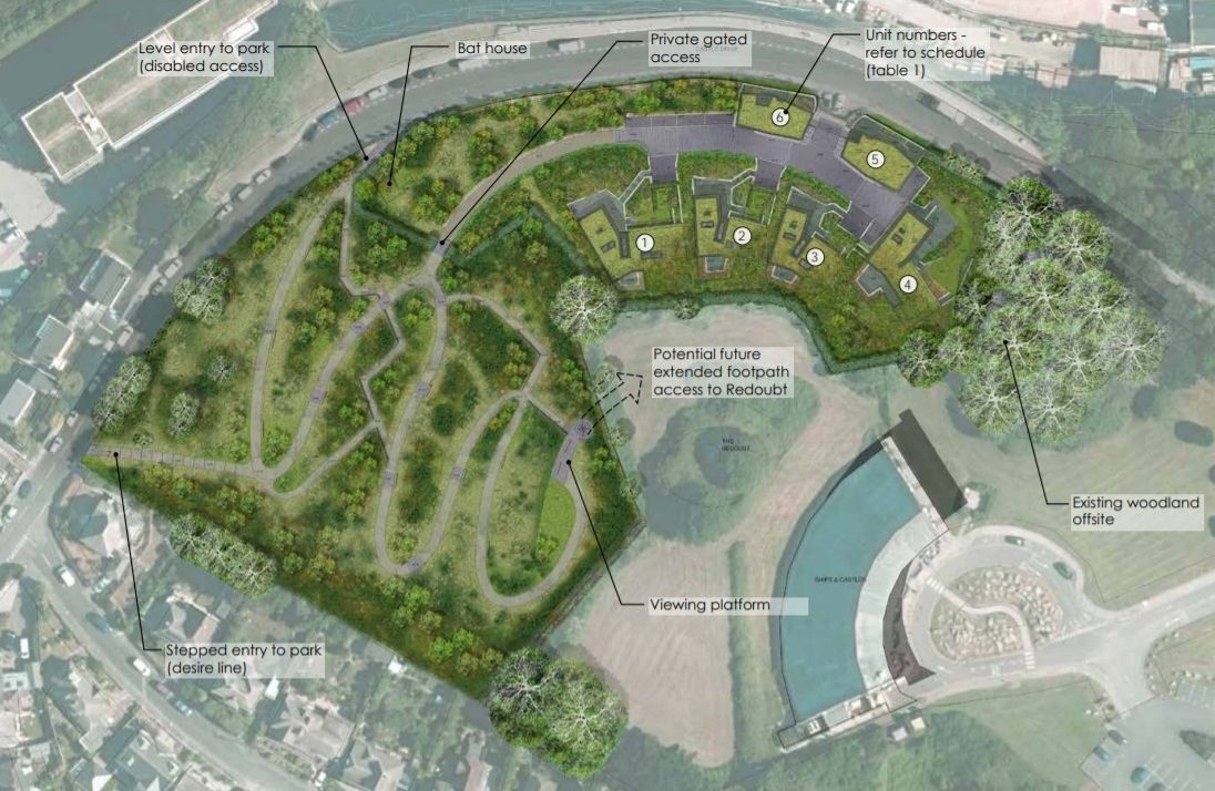
The proposed layout of the site Picture: Lavigne Lonsdale
The overall site covers 1.65 hectares, with 0.68 hectares of it associated with existing oil storage tanks, up to ten metres deep, which are buried. The proposal is to remove these as part of the development.
The document states that an initial contamination/ remediation report shows the site may be contaminated with hydrocarbons that are known to pose a risk to sensitive receptors such as controlled waters and to human health.
It adds: "The precise location and concentrations of contamination that may be present will be established and fully addressed on receipt of planning in the form of a condition."
The architects point out that the south west coast path passes along Castle Drive, adding: "The current developed element of the site currently has a negative impact on the character and appearance of the conservation area and to the setting of the scheduled monument.
"Consequently, there is an opportunity to enhance the area.
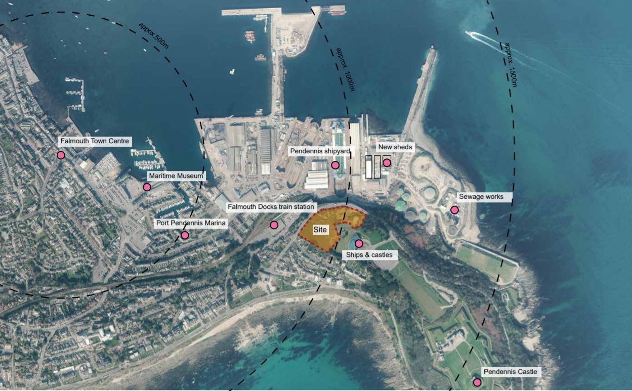
Aerial photograph showing the site in the context of the docks and Pendennis Castle Picture: Lavigne Lonsdale
"Opening the undeveloped part of the site to public access provides access to views from the headland that would improve the legibility of the conservation area’s significance and that too of the historic fortifications within their setting."
The proposals show two parking spaces per property as a minimum, made "slightly oversized" to ensure that larger vehicles have space to park, with these being at a lower level to avoid them being seen.
Other plans include allowing the buildings to be ventilated through mechanical means without having to open windows, with green roofs on the houses to help aid the thermal efficiency and insulation, and a covenant on all properties to prevent the inclusion of sheds, parasols and trampolines, other than those that can be buried.


Comments: Our rules
We want our comments to be a lively and valuable part of our community - a place where readers can debate and engage with the most important local issues. The ability to comment on our stories is a privilege, not a right, however, and that privilege may be withdrawn if it is abused or misused.
Please report any comments that break our rules.
Read the rules hereLast Updated:
Report this comment Cancel